

Did you know that both Google Maps and Google Earth include tools that will automatically measure both distance and area for you? No more guessing distances based on the map scale. Now you can measure precise distances of travel, exact property plot sizes, and even the land area of entire states or provinces.
The good news is that accomplishing this isn’t complicated or time-consuming. You just need to know the process. Here’s how to measure distance and area using Google Maps or Google Earth.
How Distance and Scale Work in Google Maps

If you’ve used Google Maps at all, you’ve probably noticed the scale that appears in the lower right corner of the screen.
Sure, you could stick a ruler on your screen and measure the equivalent of a mile; or you could mark off the distance on a slip of paper and use that to measure the roads or trails you want to travel—but you don’t have to do that. Google Maps includes easy to use tools to precisely measure both distances and areas on the map that you’re viewing.
How to Measure Distance in Google Maps
You can easily measure distance in Google Maps using built-in tools. Measuring between two points will follow an “as the crow flies” route. However, you can add multiple points to track a path more accurately.
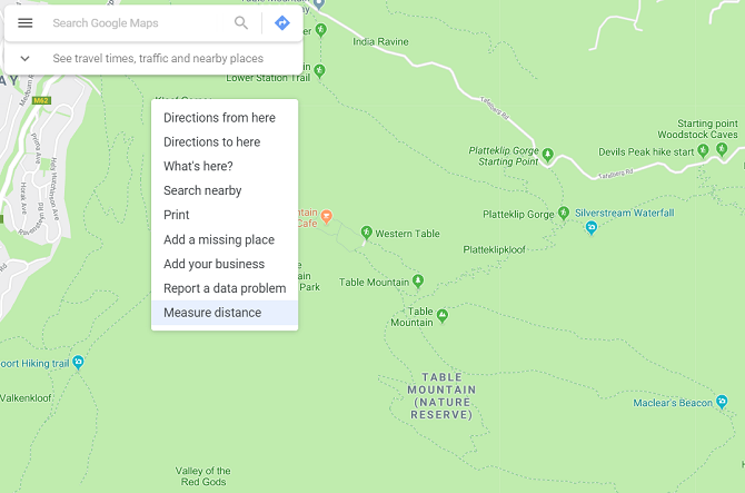
First, right-click on the starting point, and select Measure distance on the menu that pops up.
Click on the second point (the destination that you want to measure to from your starting point) on the map. Once this point is selected, Maps will automatically show the distance between both points.
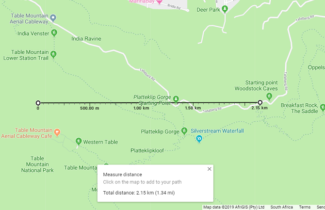
You can view the exact distance on the measuring line or with the Measure distance popup menu that appears at the bottom of the menu.
If you want to add more points to your measurement, simply click additional points on the map

If you want to trace a path, rather than a straight line, simply add multiple points along a route to get an accurate measure of the distance you need to travel. This is especially useful when it comes to measuring the distance of a hiking trail, for example.
You can also adjust points by dragging them to a new location with your mouse.
As you trace the path, the distance will keep updating in the popup at the bottom of the map. Once you’re done tracing the trail or road as best you can, you’ll have a precise measurement of the total distance.
When finished, clear out your traced waypoints and measurements by right-clicking on the map and selecting Clear measurement from the menu.
How to Calculate Area in Google Maps
With Google Maps, you can also measure the area of a location. If you want to specifically check the area of a property, you will need to zoom in. Once close enough, Google will show the property boundaries if they are available. You can also switch between map and satellite view if this makes discerning property walls easier
To measure any area in Google Maps, you just need to start with the same process as for measuring distance.
First, right-click on the map at your starting point and choose the Measure distance option. 
Add points around the location’s boundary. Once you close the shape by clicking on the starting point, Google will automatically calculate the area of your shape.
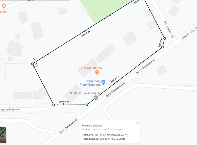
You’ll see the total area in square footage and square meters, and the total distance in feet and meters at the bottom of the screen.
How Distance Works in Google Earth

Google Maps is good enough, so why bother using Google Earth to measure distance or area? Well, Google Earth is actually a little bit more powerful than Google Maps when it comes to doing measurements.
With Google Earth, you can measure the distance and area just like you do in Maps, but you can also use some interesting tools that let you:
- See altitude
- Save all your measurements
- Measure 3D objects’ height and area, such as the height or width of a building
Let’s take a look at how you can do all this with Google Earth…
How to Measure Distance in Google Earth
Google Earth is more detailed than Google Maps, but measuring distance with Google Earth works in a similar way.
You will first need to launch Google Earth in your Chrome browser and select the location you want to see. To start measuring, select the ruler icon at the bottom of the left-hand sidebar.
![]()
Once you click this icon, Google Earth will switch to a top-down view and ask you to select your starting point. A small popup will also appear on the top-right of the window, showing distance.

As you select more than one point, this popup will update with the total distance measured.

When you select Done, you can start a new measurement if you want to. You can also change the measurement units, converting them to kilometers, yards, nautical miles, or other units.
If you want to measure the distance for something like a mountain trail, you can switch to 3D view after selecting the ruler icon. This lets you measure large objects such as mountains, or accurately trace a path along an incline.

How to Measure Area in Google Earth
Google Earth also lets you measure the area of large plots or locations, but also much smaller areas such as the roof of a building.
For a large area, you simply need to outline the perimeter of the location you want to measure. You will start off the same way as when measuring distance, with the ruler icon.
Once you select multiple points and close the outline by selecting your starting point again, Google Earth will automatically calculate area.

Again, you can drag points to change the outline or switch between units of measurement.
How to Measure 3D Objects and Buildings With Google Earth Pro
When it comes to measuring 3D objects such as buildings, you will need to use the Google Earth Pro standalone software. The program is free to use but you need to download and install it on your PC.
The more powerful tools in Google Earth Pro allow you to measure these smaller 3D objects, that Google Earth’s browser version cannot do.
Measuring 3D Object and Building Heights and Widths in Google Earth Pro
Once you’ve installed and opened Google Earth Pro, go to the building you want to measure by using the search bar. Google will then center on this location.
Next, tilt your view to the correct angle for measuring by using the shortcuts Shift + Up Arrow or Shift + Down Arrow.

Click the ruler icon and a new popup will open with various measurement tools. 
Choose 3D polygon to measure the height or width of a building. Then, click on the points you want to measure the distance between. The measurement window will automatically update with the distance.
If you want to adjust your points, you can drag them with your mouse. However, adding additional points will result in an area calculation.
How to Measure Area of 3D Object in Google Earth Pro
To measure the area of a 3D object, you will need to add more than two points. At three points, Google Earth Pro automatically connects all your points and calculates the area. For example, once you add the third point, a triangle is generated. Adding a fourth point creates a four-sided polygon—and additional points can be added from there.
Add as many points as needed to trace the outline of the object you are measuring.

You can drag these points to adjust the size of your shape. The area calculation automatically updates as you change the positions of points.
If you make an error, you can select the Clear option to restart your measurement. These measurements can also be saved in the Google Earth Pro program to use at a later stage.
Do More With Google Maps
Measuring is not the only thing you can do with Google Maps or Google Earth. Google has updated the tools significantly over the years to add even more functionality and convenience.
Looking for more great features? Check out our guide on Google Maps for Android features and tricks to make the most of your navigation experience.
Read the full article: How to Measure Area and Distance in Google Maps and Google Earth
from MakeUseOf https://ift.tt/2n6dO1C
via IFTTT
0 comments:
Post a Comment